Algiers Project
Download112811_cp.jpg (1.069Mb)
Alternative Titles
Algiers Plans
Urban Plan for Algiers
Project A
Date
1931-1942Description
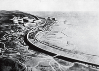
Le Corbusier's first version of his plan for the North African city of Algiers, developed between 1930 and 1933, represented the culmination of his 1920s work on urban design, and especially of his concept of the Ville radieuse. Even in its several later incarnations, the plan was also a loud demonstration of the disruptive effects of his architecture, which tended to obliterate the past in order to build a better future. Well aware of this quality, the architect called his plan the "Obus" or "shrapnel" plan. It featured a business center on the docks, where the preexisting buildings were to be torn down; a residential neighborhood on the difficult, hilly site of the Fort l'Empereur; and a giant motorway, the land below it to be filled by homes for 180,000 people. The plan was as magniloquent as it was visionary, as is evident in the right half of the drawing, where Le Corbusier's blue pencil highlights the new buildings. The plan on the left shows his vision for the new city culminating in the new buildings on the docks, marked in red on a yellow field.
The courage of Le Corbusier's Obus design, his readiness to tackle urban planning on a giant scale, influenced generations of later architects and indirectly informed the construction of a number of new cities such as Brasília. As for Le Corbusier himself, however, he continued to make new proposals until 1942, but his Algiers—like his other urban plans—was never built. aerial view, Fortel Empereur area
Type of Work
City; Plan (drawing)Subject
Unbuilt projects, Rehabilitating, Architectural theory, Algiers (Algeria), Architecture, Modern --20th century, City planning, Architecture, French, Urban planning and environment, Africa, North
Rights Statement
All rights reserved
Item is Part of
131406