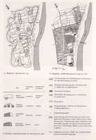
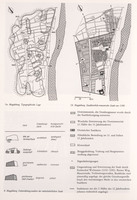
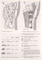
Present day map of Magdeburg compared with Magdeburg under the Holy Roman Empire
| dc.coverage.spatial | Site: depicts Magdeburg (Saxony-Anhalt, Germany) | en_US |
| dc.creator | Unknown | en_US |
| dc.date.accessioned | 2007-09-14T19:05:18Z | |
| dc.date.available | 2007-09-14T19:05:18Z | |
| dc.identifier | 112781 | en_US |
| dc.identifier.uri | http://hdl.handle.net/1721.3/21248 | en_US |
| dc.description | map, left, current map of Magdeburg, right, Magdeburg under Holy Roman Empire | en_US |
| dc.format.medium | paper (fiber product) | en_US |
| dc.format.medium | ink | en_US |
| dc.relation.ispartof | 131304 | en_US |
| dc.subject | Cartography | en_US |
| dc.subject | Comparing | en_US |
| dc.subject | Holy Roman Empire | en_US |
| dc.subject | Germany --History | en_US |
| dc.subject | Land use, Urban | en_US |
| dc.subject | Topographic maps | en_US |
| dc.title | Present day map of Magdeburg compared with Magdeburg under the Holy Roman Empire | en_US |
| dc.type | Image | en_US |
| dc.rights.access | All rights reserved | en_US |
| vra.culturalContext | German | en_US |
| vra.technique | cartography | en_US |
| vra.worktype | Map | en_US |
| dc.contributor.display | German | en_US |
Files in this item
This item appears in the following Collection(s)
-
Architecture, Urban Planning, and Visual Arts
Online Image Collection


