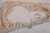
| dc.coverage.spatial | Site: probably depicts Xaca (Sicily, Italy) | en_US |
| dc.coverage.temporal | creation date: 16th century | en_US |
| dc.creator | unknown (Italian) | en_US |
| dc.date | 16th century | en_US |
| dc.date.accessioned | 2007-08-03T20:44:23Z | |
| dc.date.available | 2007-08-03T20:44:23Z | |
| dc.date.issued | 1500-1599 | en_US |
| dc.identifier | 111780 | en_US |
| dc.identifier.uri | http://hdl.handle.net/1721.3/19944 | en_US |
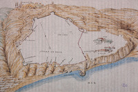
| dc.description | map, Plan of Xaca showing city limits and fortifications. | en_US |
| dc.format.medium | paper (fiber product) | en_US |
| dc.format.medium | ink | en_US |
| dc.relation.ispartof | 130690 | en_US |
| dc.subject | Cartography | en_US |
| dc.subject | Fortifications | en_US |
| dc.subject | Art, Late Renaissance | en_US |
| dc.subject | Italy --Maps | en_US |
| dc.subject | Sicily (Italy) | en_US |
| dc.subject | Spannocchi, Tiburzio, 1541-1606 | en_US |
| dc.subject | Italy History 1492-1870 | en_US |
| dc.title | Map of Xaca | en_US |
| dc.type | Image | en_US |
| dc.rights.access | All rights reserved | en_US |
| vra.culturalContext | Italian | en_US |
| vra.technique | cartography | en_US |
| vra.worktype | Map | en_US |
| dc.contributor.display | unknown (Italian) | en_US |


