| dc.coverage.spatial | Creation location: Cairo (Egypt) | en_US |
| dc.creator | unknown (Egyptian (modern)) | en_US |
| dc.date.accessioned | 2007-07-12T17:38:15Z | |
| dc.date.available | 2007-07-12T17:38:15Z | |
| dc.identifier | 111156 | en_US |
| dc.identifier.uri | http://hdl.handle.net/1721.3/19612 | en_US |
| dc.description | full view | en_US |
| dc.format.medium | paper (fiber product) | en_US |
| dc.format.medium | ink | en_US |
| dc.relation.ispartof | 130536 | en_US |
| dc.subject | Cairo (Egypt) | en_US |
| dc.subject | Egypt -- Description and travel | en_US |
| dc.subject | Islamic cities and towns | en_US |
| dc.subject | Architecture, Islamic --Egypt | en_US |
| dc.subject | Neighborhoods | en_US |
| dc.subject | Historical geography --Maps | en_US |
| dc.subject | Land use, Urban | en_US |
| dc.subject | Egypt --Maps | en_US |
| dc.subject | Cities and towns --Egypt | en_US |
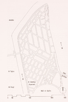
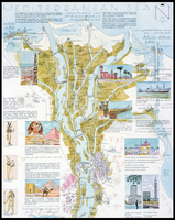
| dc.title | Schematic Plan of Az-Zamālik | en_US |
| dc.type | Image | en_US |
| dc.rights.access | All rights reserved | en_US |
| vra.culturalContext | Egyptian (modern) | en_US |
| vra.culturalContext | Islamic | en_US |
| vra.technique | cartography | en_US |
| vra.worktype | Map | en_US |
| dc.contributor.display | unknown (Egyptian (modern)) | en_US |


