| dc.coverage.spatial | Site: London (England) | en_US |
| dc.coverage.temporal | creation date: 2016 | en_US |
| dc.creator | unknown (British) | en_US |
| dc.date | 2016 | en_US |
| dc.date.accessioned | 2018-09-04T19:42:42Z | |
| dc.date.available | 2018-09-04T19:42:42Z | |
| dc.date.issued | 2016 | en_US |
| dc.identifier | 284180 | en_US |
| dc.identifier.uri | http://hdl.handle.net/1721.3/186245 | |
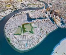
| dc.description | general view, 2017 | en_US |
| dc.description | 26 Store St, Fitzrovia, London WC1E 7BT, UK | en_US |
| dc.relation.ispartof | 144995 | en_US |
| dc.rights | (c) Richard Langendorf | en_US |
| dc.subject | Maps | en_US |
| dc.subject | Models (Representations) | en_US |
| dc.title | Building Centre Interactive Map of London | en_US |
| dc.type | Image | en_US |
| dc.rights.access | Creative Commons Attribution-NonCommercial 3.0 http://creativecommons.org/licenses/by-nc/3.0/ | en_US |
| dc.identifier.vendorcode | BuildingCenterInteractiveCityMap_London2017ga.tif | en_US |
| vra.culturalContext | British | en_US |
| vra.culturalContext | English | en_US |
| vra.worktype | Map, Model (representation) | en_US |
| dc.contributor.display | unknown (British) | en_US |

