MIT Libraries logoDome

MIT
View Item 
  • Dome Home
  • Visual Collections
  • Selected City Plans
  • View Item
  • Dome Home
  • Visual Collections
  • Selected City Plans
  • View Item
JavaScript is disabled for your browser. Some features of this site may not work without it.

Lower Manhattan Plan: Capital Project ES-1

Wallace, McHarg, Roberts, and Todd; Whittlesey, Conklin and Rossant; Alan M. Voorhees & Associates, Inc.
Thumbnail
Download277398_cp.jpg (889.2Kb)
Alternate file
277398_sv.jpg (7.387Mb)
Alternative Title
The Lower Manhattan Plan: Capital Project ES-1
URI
http://hdl.handle.net/1721.3/185485
Date
1966
Description
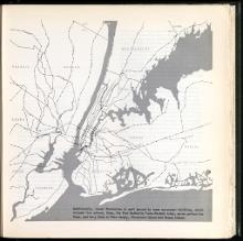
map, map of area around New York City: "Additionally, Lower Manhattan is well served by mass movement facilities, which include five subway lines, the Port Authority Trans-Hudson tubes, seven surface bus lines, and ferry lines to New Jersey, Governors Island and Staten Island.
Type of Work
Municipal plan
Subject
Urban planning, New York (N.Y.), City planning -- New York, Subways, Public transit
Item is Part of
144947
Metadata
Show full item record

Collections
  • Selected City Plans

Browse

All of DomeCommunities & CollectionsBy Issue DateCreatorsTitlesSubjectsThis CollectionBy Issue DateCreatorsTitlesSubjects

My Account

Login
MIT Libraries
PrivacyPermissionsAccessibilityContact us
MIT
Content created by the MIT Libraries, CC BY-NC unless otherwise noted. Notify us about copyright concerns.