San Francisco: Topographic Views on the Freeway
Download1A2-US-SF-TVH-A16_cp.jpg (308.5Kb)
Alternate file
Date
2014Description
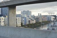
US Interstate 280 looking northeast into Mission Bay developments; Transportation in the San Francisco Bay Area is reliant on a complex multimodal infrastructure consisting of roads, bridges, highways, rail, tunnels, airports, and bike and pedestrian paths. Various agencies collectively manage several interstate highways and state routes, two subway networks, two commuter rail agencies, eight trans-bay bridges, a ferry, local bus service, three international airports, and an extensive network of roads, tunnels, and bike paths. Eight-lane and, in some parts, 10-lane freeways connect San Francisco to San Jose through the Peninsula. Source: Wikipedia; http://en.wikipedia.org/wiki/Main_Page (accessed 9/2/2015)
Type of Work
topographical view; photographSubject
cityscape, contemporary (1960 to present), Automobiles, City planning, Transportation, Twenty-first century
Rights
Rights Statement
Licensed for educational and research use by the MIT community only