San Francisco: Topographic Skyline Views
Download1A2-US-SF-SV-E17_cp.jpg (324.5Kb)
Alternate file
Date
2014Description
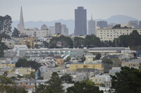
San Francisco skyline seen from the west; 555 California St. skyscraper at center; Some of San Francisco's parks, bridges and neighborhoods viewed from the Berkeley Hills. Generally there are five broad districts, counterclockwise: Central/downtown, Richmond, Sunset, Upper Market and beyond (south central) and Bernal Heights/Bayview and beyond (southeast). The San Francisco Planning Department officially identifies 36 neighborhoods within those districts but in practice there are more neighborhood names (and minor district subset names) in common use. Source: Wikipedia; http://en.wikipedia.org/wiki/Main_Page (accessed 9/2/2015)
Type of Work
topographical view; photographSubject
architecture, cityscape, contemporary (1960 to present), City planning, Twenty-first century
Rights
Rights Statement
Licensed for educational and research use by the MIT community only