Lancaster: Topographic Views
Download1A2-US-LAN-A15_cp.jpg (441.2Kb)
Alternate file
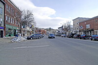
Date
2006Description
Looking south on Main at the "downtown" area of 2 blocks; As of the 2010 census, the town population was 3,507. It is the county seat of Coos County and gateway to the Great North Woods Region. Tourists come to the Weeks State Park, and the White Mountain National Forest, for hiking and skiing. The town center, or census-designated place, has a total area of 2.1 square miles. The town is part of the Berlin, NH−VT "Micropolitan" Statistical Area. Lancaster is drained by the Israel River, and is within the Connecticut River watershed. Source: Wikipedia; http://en.wikipedia.org/wiki/Main_Page (accessed 9/1/2015)
Type of Work
topographical view; photographSubject
architecture, cityscape, genre, small town, New England, Twenty-first century
Rights
Rights Statement
Licensed for educational and research use by the MIT community only