Ahmedabad: Topographic Views
Download1A2-IN-STV-D82_cp.jpg (428.9Kb)
Alternate file
Date
2014Description
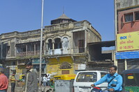
Older stone building with hexagonal cupola; Also known as Ahmadābād, located on Sābarmati river, north of Bombay (Mumbai); founded by Muslim Sultan Aḥmad Shāh, ruler of Gujarat; seized by Mughal emperor Akbar in 1572. Half of the population is employed in cotton industry; first cotton mills opened 1859-1861; has light manufacturing. With a population of more than 5.5 million and an extended population of 6.3 million, it is the sixth largest city and seventh largest metropolitan area of India. Source: Wikipedia; http://en.wikipedia.org/wiki/Main_Page (accessed 8/28/2015)
Type of Work
topographical view; photographSubject
architecture, cityscape, contemporary (1960 to present), genre, Twenty-first century
Rights
Rights Statement
Licensed for educational and research use by the MIT community only