| dc.coverage.spatial | Creation Site: Hyderābād, Andhra Pradesh, India, Asia, | en_US |
| dc.coverage.temporal | photographed 2014 (creation) | en_US |
| dc.creator | Gilchrist, Scott | en_US |
| dc.date | 2014 | en_US |
| dc.date.accessioned | 2016-06-21T19:10:34Z | |
| dc.date.available | 2016-06-21T19:10:34Z | |
| dc.date.issued | 2014 | en_US |
| dc.identifier | 264689 | en_US |
| dc.identifier.other | archrefid: 3377 | en_US |
| dc.identifier.uri | http://hdl.handle.net/1721.3/180747 | |
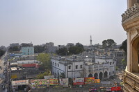
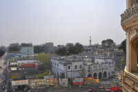
| dc.description | View of the market area viewed from the Charminar (corner visible at right); Hyderabad is the capital of the southern Indian state of Telangana and de jure capital of Andhra Pradesh. Occupying 922 square kilometres (356 sq mi) along the banks of the Musi River, it has a population of about 6.8 million and a metropolitan population of about 7.75 million, making it the fourth most populous city and sixth most populous urban agglomeration in India. Source: Wikipedia; http://en.wikipedia.org/wiki/Main_Page (accessed 9/2/2015) | en_US |
| dc.format.medium | digital images | en_US |
| dc.rights | © Scott Gilchrist, Archivision, Inc. | en_US |
| dc.subject | architecture | en_US |
| dc.subject | business, commerce and trade | en_US |
| dc.subject | cityscape | en_US |
| dc.subject | contemporary (1960 to present) | en_US |
| dc.subject | Twenty-first century | en_US |
| dc.title | Hyderabad: Topographic Views | en_US |
| dc.type | image | en_US |
| dc.rights.access | Licensed for educational and research use by the MIT community only | en_US |
| dc.identifier.vendorcode | 1A2-IN-HY-TV-A04 | en_US |
| vra.culturalContext | Indian (South Asian) | en_US |
| vra.technique | photography | en_US |
| vra.worktype | topographical view | en_US |
| vra.worktype | photograph | en_US |
| dc.contributor.display | Scott Gilchrist (Canadian distributor, born 1960) | en_US |

