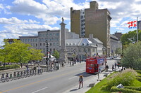
Place Jacques Cartier
Download1A2-C-M-PJC-A02_cp.jpg (522.2Kb)
Alternate file
Date
1847Description
View looking northeast across rue Notre-Dame E; Nelson's Column at center; In 1723, the Château Vaudreuil was built for Philippe de Rigaud, Marquis de Vaudreuil, and its formal gardens occupied the space that is now the square. The Chateau burned down in 1803 and it was suggested by that the space be transformed into a public square, known as New Market Place. It functioned as a farmers market until the 1950s. In 1809, Montreal's oldest public monument was raised there, Nelson's Column. In 1847, the square was renamed in honor of Jacques Cartier, the explorer. The broad, divided street slopes steeply downhill from Montreal City Hall and rue Notre-Dame to the waterfront and rue de la Commune. It is a car-free zone in the summer. Source: Wikipedia; http://en.wikipedia.org/wiki/Main_Page (accessed 6/24/2015)
Type of Work
square (open space)Subject
cityscape, City planning, Nineteenth century
Rights
Rights Statement
Licensed for educational and research use by the MIT community only