Montreal: Topographic Views from Plane
Download1A2-C-M-MAV-A29_cp.jpg (597.8Kb)
Alternate file
Date
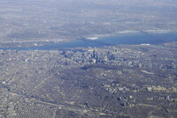
2014Description
Looking southeast over Montréal with downtown at center and the Mont-Royal Park (Parc du Mont-Royal) at center right; Montreal is the largest city in the province of Quebec, the second-largest in Canada and the 9th-largest in North America. Current 2014 estimates of the CMA place the metropolitan area of Montreal at 4.1 million. Montreal's metropolitan area (CMA) is a land area 4,259 square kilometres (1,644 sq mi). Source: Wikipedia; http://en.wikipedia.org/wiki/Main_Page (accessed 9/2/2015)
Type of Work
topographical view; photographSubject
architecture, cityscape, contemporary (1960 to present), Aerial photography in city planning, Twenty-first century
Rights
Rights Statement
Licensed for educational and research use by the MIT community only