| dc.coverage.spatial | Creation Site: Montréal, Québec, Canada, North and Central America, | en_US |
| dc.coverage.temporal | photographed 2014 (creation) | en_US |
| dc.creator | Gilchrist, Scott | en_US |
| dc.date | 2014 | en_US |
| dc.date.accessioned | 2016-06-14T14:37:23Z | |
| dc.date.available | 2016-06-14T14:37:23Z | |
| dc.date.issued | 2014 | en_US |
| dc.identifier | 263903 | en_US |
| dc.identifier.other | archrefid: 3289 | en_US |
| dc.identifier.uri | http://hdl.handle.net/1721.3/179954 | |
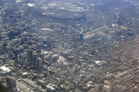
| dc.description | Downtown Montréal at left with the area just east of downtown Montréal at right; Montreal is the largest city in the province of Quebec, the second-largest in Canada and the 9th-largest in North America. Current 2014 estimates of the CMA place the metropolitan area of Montreal at 4.1 million. Montreal's metropolitan area (CMA) is a land area 4,259 square kilometres (1,644 sq mi). Source: Wikipedia; http://en.wikipedia.org/wiki/Main_Page (accessed 9/2/2015) | en_US |
| dc.format.medium | digital images | en_US |
| dc.rights | © Scott Gilchrist, Archivision, Inc. | en_US |
| dc.subject | architecture | en_US |
| dc.subject | cityscape | en_US |
| dc.subject | contemporary (1960 to present) | en_US |
| dc.subject | Aerial photography in city planning | en_US |
| dc.subject | Twenty-first century | en_US |
| dc.title | Montreal: Topographic Views from Plane | en_US |
| dc.type | image | en_US |
| dc.rights.access | Licensed for educational and research use by the MIT community only | en_US |
| dc.identifier.vendorcode | 1A2-C-M-MAV-A09 | en_US |
| vra.culturalContext | Canadian | en_US |
| vra.technique | photography | en_US |
| vra.worktype | topographical view | en_US |
| vra.worktype | photograph | en_US |
| dc.contributor.display | Scott Gilchrist (Canadian photographer, born 1960) | en_US |

