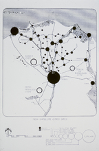
New Satellite Cities Sites
| dc.coverage.temporal | creation date: late 1970s | en_US |
| dc.creator | Unknown | en_US |
| dc.date | late 1970s | en_US |
| dc.date.accessioned | 2016-01-11T22:04:08Z | |
| dc.date.available | 2016-01-11T22:04:08Z | |
| dc.date.issued | 1976-1979 | en_US |
| dc.identifier | 249977 | en_US |
| dc.identifier.uri | http://hdl.handle.net/1721.3/176233 | |
| dc.description | map | en_US |
| dc.relation.ispartof | 144774 | en_US |
| dc.rights | (c) 1979 Gami | en_US |
| dc.subject | Egypt | en_US |
| dc.subject | Cairo (Egypt) | en_US |
| dc.subject | Egypt --Maps | en_US |
| dc.title | New Satellite Cities Sites | en_US |
| dc.title.alternative | Map of Egypt showing Cairo satellite cities, including Sadat City, Kind Khaled City, Tenth of Ramadan City, Port Said, Damanhur, Tanta, Suez, and Ismailia | en_US |
| dc.type | Image | en_US |
| dc.rights.access | All rights reserved | en_US |
| vra.culturalContext | Egyptian | en_US |
| vra.worktype | Map | en_US |
| dc.contributor.display | Egyptian | en_US |
Files in this item
This item appears in the following Collection(s)
-
Aga Khan Visual Archive
Images of architecture, urbanism, and the built environment in the Islamic world


