| dc.coverage.spatial | Site: Hibbing (Minnesota, USA) | en_US |
| dc.coverage.temporal | creation date: 1893-1894 | en_US |
| dc.creator | Cliffs Natural Resources | en_US |
| dc.date | 1893-1894 | en_US |
| dc.date.accessioned | 2015-09-14T15:31:17Z | |
| dc.date.available | 2015-09-14T15:31:17Z | |
| dc.date.issued | 1893-1894 | en_US |
| dc.identifier | 258661 | en_US |
| dc.identifier.uri | http://hdl.handle.net/1721.3/174414 | |
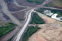
| dc.description | aerial view, road that runs between the U.S. Steel Keewatin Taconite Mine and the Hull-Rust-Mahoning open pit iron mine, 8/25/2010 | en_US |
| dc.description | Sparrows Point, MD 20219 | en_US |
| dc.relation.ispartof | 144603 | en_US |
| dc.rights | © Alex S. MacLean / Landslides | en_US |
| dc.subject | Industrial buildings | en_US |
| dc.subject | Iron mines | en_US |
| dc.subject | Minerals | en_US |
| dc.subject | Architecture, American | en_US |
| dc.subject | Architecture --United States | en_US |
| dc.subject | National Register of Historic Places | en_US |
| dc.subject | Iron industry and trade | en_US |
| dc.subject | Roads | en_US |
| dc.subject | Aerial views | en_US |
| dc.subject | Aerial photography --United States | en_US |
| dc.title | Hull-Rust-Mahoning Mine | en_US |
| dc.type | Image | en_US |
| dc.rights.access | Licensed for educational and research use by the MIT community only | en_US |
| dc.identifier.vendorcode | 140826-0508 | en_US |
| vra.culturalContext | American | en_US |
| vra.technique | construction | en_US |
| vra.worktype | Mine (extracting complex) | en_US |
| dc.contributor.display | Company: Cliffs Natural Resources (American, founded 1846) | en_US |
