| dc.coverage.spatial | Site: New Haven (Connecticut, USA) | en_US |
| dc.coverage.temporal | Creation date: New Haven Colony founded, 1638, other date: New Haven and Connecticut colonies merge, 1663 | en_US |
| dc.creator | American | en_US |
| dc.date | 1638 | en_US |
| dc.date.accessioned | 2015-09-03T15:41:32Z | |
| dc.date.available | 2015-09-03T15:41:32Z | |
| dc.date.issued | 1638 | en_US |
| dc.identifier | 258601 | en_US |
| dc.identifier.uri | http://hdl.handle.net/1721.3/174313 | |
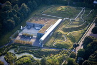
| dc.description | aerial view, the facilty is located on the suburban outskirts of New Haven, Connecticut and is a reserve water source for the South Central Connecticut Regional Water Authority. It draws water from nearby Lake Whitney, at the base of the Mill River Watershed. The site is adjacent to the Eli Whitney Museum, which commemorates the famous inventor and his son, who first dammed the adjacent Mill River for use as a water supply in 1806., 8/26/2005 | en_US |
| dc.relation.ispartof | 127443 | en_US |
| dc.rights | © Alex S. MacLean / Landslides | en_US |
| dc.subject | Planned communities | en_US |
| dc.subject | Urban planning | en_US |
| dc.subject | United States --History --Colonial period, ca. 1600-1775 | en_US |
| dc.subject | Cities and towns --Growth | en_US |
| dc.subject | Land use, Urban | en_US |
| dc.subject | New Haven (Conn.) | en_US |
| dc.subject | Aerial views | en_US |
| dc.subject | Aerial photography --United States | en_US |
| dc.subject | Water treatment plants | en_US |
| dc.title | City of New Haven | en_US |
| dc.title.alternative | New Haven Colony | en_US |
| dc.type | Image | en_US |
| dc.rights.access | Licensed for educational and research use by the MIT community only | en_US |
| dc.identifier.vendorcode | 090827-0391 | en_US |
| vra.culturalContext | American | en_US |
| vra.worktype | City | en_US |
| dc.contributor.display | American | en_US |

