City of Boston
Download258577_cp.jpg (623.6Kb)
Alternate file
Alternative Title
Shawmutt
Date
1630Description
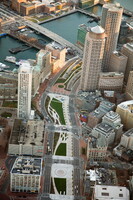
aerial view, Rose Kennedy Greenway runs from Chinatown to the North End, built over the same route as the old elevated central highway, which has been reconfigured to run underground. The Greenway serves as an important pedestrian link between the city and the waterfront, 1/1/1996
Type of Work
CitySubject
New England, Urban planning, Boston (Mass.), Cities and towns --Growth, Land use, Urban, City planning, Skyscrapers, Aerial views, Central business districts, Urban parks, Green (environmental concept), Aerial photography --United States, Rose Fitzgerald Kennedy Greenway
Rights
Rights Statement
Licensed for educational and research use by the MIT community only
Item is Part of
101195