South Boston
Download258576_cp.jpg (444.4Kb)
Alternate file
Date
1804Description
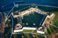
aerial view, Castle Island (which is connected to the mainland) is home to Fort Independence, a National Historic Landmark, and Pleasure Bay features a sandy beach and swimming in a calm, enclosed lagoon. Fort Independence is the eighth fort to occupy this site and contains over 172,687 linear feet of hammered stone. It was constructed under the direction of Colonel Sylvanus Thayer between 1834 and 1851., 1/1/1996
Type of Work
NeighborhoodSubject
Urban planning, Urban renewal, Neighborhoods, Land use, Urban, City planning, South Boston (Boston, Mass.), Forts, Citadels, Aerial views, Aerial photography --United States
Rights
Rights Statement
Licensed for educational and research use by the MIT community only
Item is Part of
143954