City of Detroit
Download258494_cp.jpg (810.6Kb)
Alternate file
Date
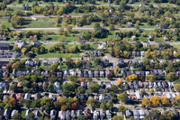
1701Description
aerial view, Alter Road (center) marks the divide between Detroit and Grosse Point, the city's wealthier neighbor; the foreground of Grosse Point suggests the density that once was in Detroit, 2014
Type of Work
CitySubject
Urban planning, Detroit (Mich.), Land use, Urban, Cities and towns -- United States, Houses, Aerial views, Theological virtues, Housing, Density, Aerial photography --United States, Single-family dwellings
Rights
Rights Statement
Licensed for educational and research use by the MIT community only
Item is Part of
140270