MIT Libraries logoDome

MIT
View Item 
  • Dome Home
  • Visual Collections
  • Aerial Photography
  • View Item
  • Dome Home
  • Visual Collections
  • Aerial Photography
  • View Item
JavaScript is disabled for your browser. Some features of this site may not work without it.

City of Detroit

American
Thumbnail
Download258396_cp.jpg (593.6Kb)
Alternate file
258396_sv.jpg (1.829Mb)
URI
http://hdl.handle.net/1721.3/173610
Date
1701
Description
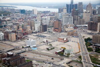
aerial view, the Fisher Freeway (bottom) meets Grand River Avenue (right), leading in to downtown Detroit; this area on the edge of downtown hosts more empty lots than buildings, a majority of which serve as gravel or macadam surface parking, 2014
Type of Work
City
Subject
Urban planning, Detroit (Mich.), Land use, Urban, Cities and towns -- United States, Highways, Aerial views, Parking lots, Vacant lots, Central business districts, Aerial photography --United States
Rights
© Alex S. MacLean / Landslides
Rights Statement
Licensed for educational and research use by the MIT community only
Item is Part of
140270
Metadata
Show full item record

Collections
  • Aerial Photography

Browse

All of DomeCommunities & CollectionsBy Issue DateCreatorsTitlesSubjectsThis CollectionBy Issue DateCreatorsTitlesSubjects

My Account

Login
MIT Libraries
PrivacyPermissionsAccessibilityContact us
MIT
Content created by the MIT Libraries, CC BY-NC unless otherwise noted. Notify us about copyright concerns.