Lost Dutchman State Park: Topographic Views
Download2A2-US-SP-LD-A04_cp.jpg (647.8Kb)
Alternate file
Date
2012Description
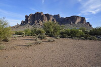
Desert butte in the Superstition Mountains; Lost Dutchman State Park is a 320-acre (129 ha) state park located near the Superstition Mountains in central Arizona, and named after the Lost Dutchman's Gold Mine, a famous gold mine legendary among the tales of the Old West. The park also acts as a trailhead for the trails leading into the Tonto National Forest in which the Superstition Mountains (and the Lost Dutchman mine) are located. Source: Wikipedia; http://en.wikipedia.org/wiki/Main_Page (accessed 7/22/2014)
Type of Work
topographical view; photographSubject
landscape, parks (recreation areas), conservation, Twenty-first century
Rights
Rights Statement
Licensed for educational and research use by the MIT community only