| dc.coverage.spatial | Site: Québec, Québec, Canada | en_US |
| dc.coverage.temporal | opened 2008 (creation) | en_US |
| dc.creator | BGLA | en_US |
| dc.date | 2008 | en_US |
| dc.date.accessioned | 2015-01-05T18:13:31Z | |
| dc.date.available | 2015-01-05T18:13:31Z | |
| dc.date.issued | 2008 | en_US |
| dc.identifier | 255639 | en_US |
| dc.identifier.other | archrefid: 2977 | en_US |
| dc.identifier.uri | http://hdl.handle.net/1721.3/171573 | |
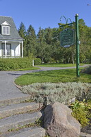
| dc.description | Maison Dorion-Coulombe, a restored house ca. 1775, serves as Interpretation Center, detail, signage; The Parc linéaire des rivières Saint-Charles et du Berger is a 32 km (19.2 mi.) long pedestrian trail following the river on its whole course. It goes through Quebec City downtown and continues northwards through natural habitat. Its development is linked to the cleanup and redevelopment of the banks of the river, which consisted of removal of 8 km of shoreline concrete, replanting habitat and creation of retention ponds to guard against pollution. The trail crosses several city parks. Sites of interest include the Kabir Kouba waterfall, a canyon, a bog covered with a wooden boardwalk, a full forest zone, a lake, a water "castle" (old treatment plant), historic buildings, a Wyandot village (Wendake) and public artworks. The Park includes the historic Maison Dorion-Coulombe, built ca. 1775. It was saved from demolition and moved twice from its original location in Vanier by private owners; acquired by the City of Quebec in 2000 and restored to serve as the Park's Intrepretation Center. The Centre écologique Léopold-E.-Beaulieu (433 Rue Delage) was built by Brière Gilbert et associés, architectes. The Park trail also crosses the Cartier-Brébeuf National Historic Site, on the north shore in the La Cité-Limoilou borough, at the confluence with the Lairet River. Source: Wikipedia; http://en.wikipedia.org/wiki/Main_Page (accessed 7/30/2014) | en_US |
| dc.format.medium | paving; stone; wood; plant materials | en_US |
| dc.rights | © Scott Gilchrist, Archivision, Inc. | en_US |
| dc.subject | botanical | en_US |
| dc.subject | contemporary (1960 to present) | en_US |
| dc.subject | landscape | en_US |
| dc.subject | parks (recreation areas) | en_US |
| dc.subject | Rivers | en_US |
| dc.subject | estuary | en_US |
| dc.subject | wildlife conservation | en_US |
| dc.subject | riparian habitat | en_US |
| dc.subject | Twenty-first century | en_US |
| dc.title | Parc linéaire de la rivière Saint-Charles | en_US |
| dc.title.alternative | Linear Park on the Saint Charles River | en_US |
| dc.title.alternative | Parc linéaire des rivières Saint-Charles et du Berger | en_US |
| dc.type | image | en_US |
| dc.rights.access | Licensed for educational and research use by the MIT community only | en_US |
| dc.identifier.vendorcode | 2A2-C-QC-PLSC-C05 | en_US |
| vra.culturalContext | Canadian | en_US |
| vra.technique | construction (assembling), gardening | en_US |
| vra.worktype | riverfront | en_US |
| vra.worktype | parks (recreation areas) | en_US |
| dc.contributor.display | BGLA (Canadian architectural firm, founded 1976) | en_US |

