| dc.creator | unknown (American) | en_US |
| dc.date.accessioned | 2007-03-15T20:55:33Z | |
| dc.date.available | 2007-03-15T20:55:33Z | |
| dc.identifier | 105583 | en_US |
| dc.identifier.uri | http://hdl.handle.net/1721.3/17099 | en_US |
| dc.description | full view | en_US |
| dc.format.medium | paper (fiber product) | en_US |
| dc.format.medium | ink | en_US |
| dc.relation.ispartof | 129580 | en_US |
| dc.subject | Cartography | en_US |
| dc.subject | Harbors | en_US |
| dc.subject | Boston (Mass.) | en_US |
| dc.subject | United States --History --Colonial period, ca. 1600-1775 | en_US |
| dc.subject | Charles River (Mass.) | en_US |
| dc.subject | United States -- Maps | en_US |
| dc.subject | Historical geography --Maps | en_US |
| dc.subject | Land use, Urban | en_US |
| dc.subject | Great Britain --Colonies --America | en_US |
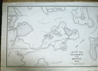
| dc.title | Historical Map of Boston, Shawmut Peninsula | en_US |
| dc.title.alternative | Map of Shawmut or Boston, 1630, at the time of settlement by the Winthrop Colony | en_US |
| dc.type | Image | en_US |
| dc.rights.access | All rights reserved | en_US |
| vra.culturalContext | American | en_US |
| vra.technique | printing | en_US |
| vra.technique | cartography | en_US |
| vra.worktype | Map | en_US |
| dc.contributor.display | unknown (American) | en_US |


