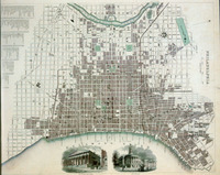
| dc.coverage.spatial | Publication location: London (England) | en_US |
| dc.coverage.temporal | creation date: ca. 1840 | en_US |
| dc.creator | Charles Knight & Co | en_US |
| dc.date | ca. 1840 | en_US |
| dc.date.accessioned | 2007-03-15T20:55:25Z | |
| dc.date.available | 2007-03-15T20:55:25Z | |
| dc.date.issued | 1835-1845 | en_US |
| dc.identifier | 105640 | en_US |
| dc.identifier.uri | http://hdl.handle.net/1721.3/17096 | en_US |
| dc.description | full view | en_US |
| dc.format.extent | 37.9 x 30.5 cm (14.92 x 12.01 inches) | en_US |
| dc.format.medium | paper (fiber product) | en_US |
| dc.format.medium | ink | en_US |
| dc.relation.ispartof | 129657 | en_US |
| dc.subject | Urban planning | en_US |
| dc.subject | United States -- Maps | en_US |
| dc.subject | Delaware River (N.Y.-Del. and N.J.) | en_US |
| dc.subject | Urbanization | en_US |
| dc.subject | Historical geography --Maps | en_US |
| dc.subject | Cities and towns --Growth | en_US |
| dc.subject | Land use, Urban | en_US |
| dc.subject | City planning | en_US |
| dc.subject | Philadelphia (Pa.) | en_US |
| dc.subject | Engraving, English | en_US |
| dc.subject | Schuylkill River (Pa.) | en_US |
| dc.title | Historical Map of Philadelphia | en_US |
| dc.type | Image | en_US |
| dc.rights.access | All rights reserved | en_US |
| vra.culturalContext | British | en_US |
| vra.culturalContext | American | en_US |
| vra.technique | engraving (incising) | en_US |
| vra.technique | printing | en_US |
| vra.worktype | Map | en_US |
| dc.contributor.display | publisher: Charles Knight & Co (British, 19th century) | en_US |


