Amsterdam Streets: Topographic Views
Download1A2-N-A-STV-A20_cp.jpg (522.8Kb)
Alternate file
Date
2013Description
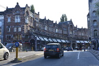
Nineteenth century building block with covered arcade on Raadhuisstraat (Keizergracht near Westermarkt) in the area known as Grachtengordel-West; Topographical shots taken both inside and outside the 17th century inner canal ring (the Grachtengordel). In the 19th and 20th centuries, the city expanded, and many new neighborhoods and suburbs were planned and built. The Jordaan area is a former working class neighborhood. The Damrak is an avenue and partially filled in canal at the center of Amsterdam, running between Amsterdam Centraal in the north and Dam Square in the south. It is the main street where people arriving at the station enter the center of Amsterdam. Also it is one of the two GVB tram routes from the station into the center (16 tram total current tram routes). Source: Wikipedia; http://en.wikipedia.org/wiki/Main_Page (accessed 7/15/2014)
Type of Work
topographical viewSubject
architecture, cityscape, contemporary (1960 to present), Twenty-first century
Rights
Rights Statement
Licensed for educational and research use by the MIT community only