Rome: Topographic Aerial Views [from airplane]
Download1A2-I-R-AVTV-A01_cp.jpg (645.0Kb)
Alternate file
Date
2009Description
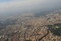
Approach to the central Rome area; St. Peter's dome visible at upper right; Rome is the capital of Italy and also of the Province of Rome and of the region of Lazio. With 2.9 million residents in 1,285.3 km2 (496.3 sq. mi.), it is also the country's largest and most populated comune and fourth-most populous city in the European Union. Vatican City is an independent country within the city boundaries of Rome, the only existing example of a country within a city: for this reason Rome has been often defined as capital of two states. Rome's history spans more than two and a half thousand years. Source: Wikipedia; http://en.wikipedia.org/wiki/Main_Page (accessed 8/4/2014)
Type of Work
topographical view; photographSubject
architecture, cityscape, contemporary (1960 to present), Aerial photography in city planning, Twenty-first century
Rights
Rights Statement
Licensed for educational and research use by the MIT community only