Mumbai: Sion Pottery district; Topographic Street Views
Download1A2-IN-STV-B19_cp.jpg (516.9Kb)
Alternate file
Date
2011Description
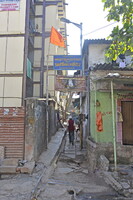
Narrow lane between modern building on left and smaller older houses; Sion is the last locality within the City limits of Mumbai, to the south. In the 17th century the village formed the boundary between Mumbai and Salsette Island. The name comes from Portuguese Jesuits (who controlled the area from 1543) who built a chapel on the hill near the present-day railway station and named it after Mount Zion (Sion) in Jerusalem. The Dharavi slum lies just to the north east. Source: Wikipedia; http://en.wikipedia.org/wiki/Main_Page (accessed 7/26/2014)
Type of Work
topographical view; photographSubject
cityscape, contemporary (1960 to present), Twenty-first century
Rights
Rights Statement
Licensed for educational and research use by the MIT community only