| dc.coverage.spatial | Site: Alberta (Canada) | en_US |
| dc.coverage.temporal | other date: start of production, 1967 | en_US |
| dc.creator | Canadian | en_US |
| dc.date | 1967 | en_US |
| dc.date.accessioned | 2014-12-02T15:03:17Z | |
| dc.date.available | 2014-12-02T15:03:17Z | |
| dc.date.issued | 1967 | en_US |
| dc.identifier | 249205 | en_US |
| dc.identifier.uri | http://hdl.handle.net/1721.3/165337 | |
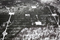
| dc.description | aerial view, network of exploratory well pads and seismic testing lines through the boreal forest, 4/4/2014 | en_US |
| dc.relation.ispartof | 144262 | en_US |
| dc.rights | © Alex S. MacLean / Landslides | en_US |
| dc.subject | Mining | en_US |
| dc.subject | Oil sands -- Alberta | en_US |
| dc.subject | Athabasca Tar Sands (Alta.) | en_US |
| dc.subject | Forests | en_US |
| dc.subject | Aerial views | en_US |
| dc.subject | Aerial photography -- Canada | en_US |
| dc.title | Alberta Oil Sands Mines | en_US |
| dc.title.alternative | Alberta Tar Sands Mines | en_US |
| dc.type | Image | en_US |
| dc.rights.access | Licensed for educational and research use by the MIT community only | en_US |
| dc.identifier.vendorcode | 140406-0523 | en_US |
| vra.culturalContext | Canadian | en_US |
| vra.worktype | Mine (extracting complex) | en_US |
| dc.contributor.display | Canadian | en_US |

