| dc.coverage.spatial | Site: Île-de-France (France) | en_US |
| dc.coverage.temporal | creation date: original settlement, 3rd century BCE, other date: renamed Paris, early 4th century CE | en_US |
| dc.creator | French | en_US |
| dc.date | 3rd century BCE | en_US |
| dc.date.accessioned | 2014-09-25T15:50:48Z | |
| dc.date.available | 2014-09-25T15:50:48Z | |
| dc.date.issued | -299--200 | en_US |
| dc.identifier | 249626 | en_US |
| dc.identifier.uri | http://hdl.handle.net/1721.3/164052 | |
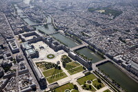
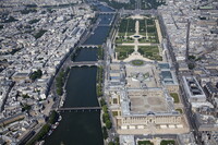
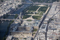
| dc.description | aerial view, the Île de la Cité is one of two remaining natural islands in the Seine within the city of Paris. It is the center of Paris and the location where the medieval city was refounded. In addition, it's where the Notre-Dame cathedral is located., 5/28/2010 | en_US |
| dc.relation.ispartof | 138144 | en_US |
| dc.rights | © Alex S. MacLean / Landslides | en_US |
| dc.subject | Urban planning | en_US |
| dc.subject | Land use, Urban | en_US |
| dc.subject | Cities and towns -- France | en_US |
| dc.subject | City planning -- France | en_US |
| dc.subject | Aerial views | en_US |
| dc.subject | Islands | en_US |
| dc.subject | Seine River (France) | en_US |
| dc.subject | Notre-Dame de Paris (Cathedral) | en_US |
| dc.subject | Ile de la Cité (Paris, France) | en_US |
| dc.subject | Aerial photography -- France | en_US |
| dc.title | City of Paris | en_US |
| dc.type | Image | en_US |
| dc.rights.access | Licensed for educational and research use by the MIT community only | en_US |
| dc.identifier.vendorcode | 100528-0066 | en_US |
| vra.culturalContext | French | en_US |
| vra.technique | construction | en_US |
| vra.worktype | City | en_US |
| dc.contributor.display | French | en_US |