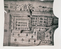
Plan of the Gobelins Quarter, Paris
| dc.coverage.spatial | Site: Paris (France) | en_US |
| dc.creator | unknown (French) | en_US |
| dc.date.accessioned | 2007-01-30T21:49:10Z | |
| dc.date.available | 2007-01-30T21:49:10Z | |
| dc.identifier | 101355 | en_US |
| dc.identifier.uri | http://hdl.handle.net/1721.3/15653 | en_US |
| dc.description | full view | en_US |
| dc.format.medium | ink | en_US |
| dc.format.medium | parchment | en_US |
| dc.relation.ispartof | 129215 | en_US |
| dc.rights | (c) Jacqueline Tatom 1993 | en_US |
| dc.subject | Cartography | en_US |
| dc.subject | Paris (France) | en_US |
| dc.subject | Cities and towns | en_US |
| dc.subject | Historical geography --Maps | en_US |
| dc.subject | Drawing, French | en_US |
| dc.subject | City planning | en_US |
| dc.title | Plan of the Gobelins Quarter, Paris | en_US |
| dc.type | Image | en_US |
| dc.rights.access | All rights reserved | en_US |
| dc.identifier.vendorcode | 2 | en_US |
| dc.publisher.institution | Repository: Archives nationales (Paris, France) | en_US |
| vra.culturalContext | French | en_US |
| vra.technique | drawing (image-making) | en_US |
| vra.worktype | Drawing (visual work) | en_US |
| vra.worktype | Plan (map) | en_US |
| dc.contributor.display | unknown (French) | en_US |
Files in this item
This item appears in the following Collection(s)
-
Architecture, Urban Planning, and Visual Arts
Online Image Collection


