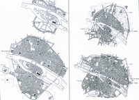
Plan of Paris in the Early Middle Ages
Download101354_cp.jpg (310.9Kb)
Alternative Titles
Plan of Paris, 1180-1225
Plan of Paris, ca. 1370
Plan of Paris, 1676
Description
comparative material, Historical plans of Paris in early Middle Ages (top left), 1180-1225 (bottom left), ca. 1370 (top right), 1676 (bottom right)
Type of Work
Plan (map)Subject
Cartography, Paris (France), Urban planning, City walls, Louvre (Paris, France), Seine River (France), France --History --Louis XIV, 1643-1715, Ile de la Cité (Paris, France), France --History --Philip II Augustus, 1180-1223, France --History --To 987, Historical geography --Maps, Cities and towns --Growth, City planning, France --History --Charles V, 1364-1380
Rights Statement
All rights reserved
Item is Part of
129211129288129289129290


