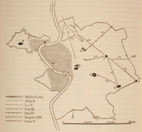
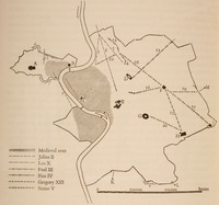
Map of Post-Ancient Rome
| dc.coverage.spatial | Site: Rome (Italy) | en_US |
| dc.creator | unknown (unidentified) | en_US |
| dc.date.accessioned | 2007-01-09T23:42:22Z | |
| dc.date.available | 2007-01-09T23:42:22Z | |
| dc.identifier | 106950 | en_US |
| dc.identifier.uri | http://hdl.handle.net/1721.3/15324 | en_US |
| dc.description | plan (drawing), streets planned in the 16th century | en_US |
| dc.relation.ispartof | 128666 | en_US |
| dc.subject | Rome (Italy) | en_US |
| dc.subject | Urban planning | en_US |
| dc.subject | Plazas | en_US |
| dc.subject | Urbanization | en_US |
| dc.subject | Cities and towns --Growth | en_US |
| dc.subject | Land use, Urban | en_US |
| dc.subject | City planning | en_US |
| dc.subject | Architecture -- Italy | en_US |
| dc.title | Map of Post-Ancient Rome | en_US |
| dc.type | Image | en_US |
| dc.rights.access | All rights reserved | en_US |
| vra.culturalContext | Italian | en_US |
| vra.worktype | Plan (map) | en_US |
| dc.contributor.display | unknown (unidentified) | en_US |
Files in this item
This item appears in the following Collection(s)
-
Architecture, Urban Planning, and Visual Arts
Online Image Collection


