New York: Topographic Street Scenes
Download1A2-US-NYTSC-A14_cp.jpg (469.3Kb)
Date
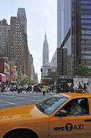
2011Description
Empire State Building, seen from West 34th St. and 8th Ave. in front of One Penn Plaza; Street scenes in mid-town Manhattan including Herald and Greeley Squares. Herald Square is formed by the intersection of Broadway, Sixth Avenue (officially named Avenue of the Americas) and 34th Street in the borough of Manhattan in New York City. The intersection is a typical Manhattan bow-tie square that consists of two named sections: Herald Square to the north (uptown) and Greeley Square to the south (downtown). Greeley Square lies between West 32nd Street and West 33rd Street and between Broadway and Sixth Avenue, and is taken up almost entirely by a triangular park. Source: Wikipedia; http://en.wikipedia.org/wiki/Main_Page (accessed 8/12/2013)
Type of Work
topographical view; photographSubject
architecture, cityscape, contemporary (1960 to present), City planning, Twenty-first century
Rights
Rights Statement
Licensed for educational and research use by the MIT community only