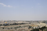
Jerusalem: Topographic Views
Gilchrist, Scott

Download1A2-IS-J-JTV-A03_cp.jpg (324.7Kb)
Date
2009Description
Looking down from the peak of Mount of Olives, northwest across 417 highway at Dome of the Rock, left; Views of Jerusalem's Old City taken from the peak of the Mount of Olives, looking west. The Mount of Olives is a mountain ridge east of and adjacent to the Jerusalem's Old City. It is named for the olive groves that once covered its slopes. The southern part of the Mount was the necropolis of the ancient Judean kingdom. The Mount is central to Jewish tradition since it has been used as a Jewish cemetery for over 3,000 years and holds approximately 150,000 graves. Due west of the Mount lies the Dome of the Rock whose golden dome is visible for miles. To the north lies the modern settlement of al Sawana. Source: Wikipedia; http://en.wikipedia.org/wiki/Main_Page (accessed 8/8/2013)
Type of Work
topographical view; photographSubject
agriculture, cityscape, landscape, necropolis, Twenty-first century
Rights
Rights Statement
Licensed for educational and research use by the MIT community only