Edinburgh: Topographic Views of Old Town
Download1A2-SC-E-TVOT-A23_cp.jpg (667.1Kb)
Date
2009Description
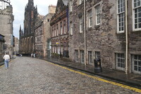
Former Tolbooth Highland St John's Church, on left, Castlehill leading to the Royal Mile; The Old Town of Edinburgh, the capital of Scotland, is the oldest part of the city. Together with the 18th-century New Town, it is a UNESCO World Heritage Site. It has preserved its medieval plan and many Reformation-era buildings. One end is closed by Edinburgh Castle and the main artery, the Royal Mile, leads away from it, down to Holyrood Palace and the ruined Holyrood Abbey. Narrow closes (alleyways), often no more than a few feet wide, lead downhill on either side of the main spine in a herringbone pattern. Source: Wikipedia; http://en.wikipedia.org/wiki/Main_Page (accessed 7/5/2012)
Type of Work
topographical view; photographSubject
architecture, cityscape, contemporary (1960 to present), City planning, Restoration and conservation, Twenty-first century
Rights
Rights Statement
Licensed for educational and research use by the MIT community only