London: Topographic Views of Kensington, Earl's Court
Download1A2-E-L-VL-A18_cp.jpg (584.8Kb)
Date
2007Description
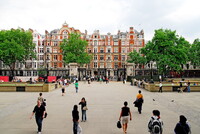
Area near the Earl’s Court Tube station; Kensington is a district of west and central London. An affluent and densely-populated area, its commercial heart is Kensington High Street and it contains the well-known museum district of South Kensington. To the north, Kensington is bordered by Notting Hill; to the east, by Brompton and Knightsbridge; to the south, by Chelsea and Earl's Court; and to the west, by Hammersmith and Shepherd's Bush. Earl's Court is the less affluent but up-and-coming area. The population density has come about through the subdivision of large mid-rise Victorian and Georgian terraced houses (generally of some four to six floors) into flats. Source: Wikipedia; http://en.wikipedia.org/wiki/Main_Page (accessed 5/10/2011)
Type of Work
topographical view; photographSubject
architecture, business, commerce and trade, City planning, Housing, gentrification, Twenty-first century
Rights
Rights Statement
Licensed for educational and research use by the MIT community only