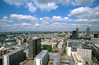
London: Topographic Views from around St. Paul's (the City)
Gilchrist, Scott

Download1A2-E-L-LVS-B1_cp.jpg (512.3Kb)
Date
1998Description
View looking northwest; The City of London is a small area within Greater London, England. It is the historic core of London around which the modern conurbation grew and has held city status since time immemorial. The City’s boundaries have remained almost unchanged since the Middle Ages, and it is now only a tiny part of the metropolis of London, though remains a notable part of central London. It is often referred to as the City (often written on maps as "City") or the Square Mile, as it is just over one square mile (1.12 sq mi/2.90 km2) in area. These terms are also often used as metonyms for the United Kingdom's financial services industry, which has historically been based here. It is a ceremonial county. Source: Wikipedia; http://en.wikipedia.org/wiki/Main_Page (accessed 5/8/2011)
Type of Work
topographical view; photographSubject
architecture, business, commerce and trade, cityscape, City planning, Twentieth century
Rights
Rights Statement
Licensed for educational and research use by the MIT community only