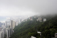
Hong Kong: Topographic Views from Victoria Peak
Gilchrist, Scott

Download1A2-CH-HK-TVFP-A20_cp.jpg (315.4Kb)
Date
2009Description
View of luxury residences on The Peak, overlooking Hong Kong and the harbor; Victoria Peak is also known as Mount Austin, and locally as The Peak. The mountain is located in the western half of Hong Kong Island. With an altitude of 552 m (1,811 ft), it is the highest mountain on the island proper. The actual summit of Victoria Peak is occupied by a radio telecommunications facility and is closed to the public. However, the surrounding area of public parks and high-value residential land is the area that is normally meant by the name The Peak. It is a major tourist attraction which offers views over central Hong Kong, Victoria Harbour, and the surrounding islands. Wealthy Europeans had their homes on the Peak, which was further developed by the opening of the Peak Tram funicular in 1888. The area was reserved for non-Chinese only until 1930. Source: Wikipedia; http://en.wikipedia.org/wiki/Main_Page (accessed 4/22/2011)
Type of Work
topographical view; photographSubject
business, commerce and trade, cityscape, contemporary (1960 to present), landscape, City planning, Great Britain--Colonies, Twenty-first century
Rights
Rights Statement
Licensed for educational and research use by the MIT community only