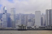
Hong Kong: Topographic Views of Victoria Harbour Shoreline
Gilchrist, Scott

Download1A2-CH-HK-TVFK-B10_cp.jpg (389.8Kb)
Date
2009Description
Shoreline of Central District with the Star Ferry Pier (Hong Kong side); Topographic and urban views shot from the south, from the Kowloon pennisula side (Tsim Sha Tsui) of Victoria Harbour, looking north at the Hong Kong island shoreline and the city of Victoria. Victoria City, or statutorily, the City of Victoria, was one of the first urban settlements in Hong Kong after it became a British colony in 1841. It was initially named Queenstown but was soon known as Victoria. It was often said to be the capital of Hong Kong, and almost all government departments still have their head offices located in the area. The city name Victoria has been eclipsed by Central District in popular usage. Source: Wikipedia; http://en.wikipedia.org/wiki/Main_Page (accessed 4/22/2011)
Type of Work
topographical view; photographSubject
business, commerce and trade, cityscape, contemporary (1960 to present), seascape, Great Britain--Colonies, habor, harbors, Twenty-first century
Rights
Rights Statement
Licensed for educational and research use by the MIT community only