Zion National Park: Topographic Views
Download2A2-US-NP-ZP-A8_cp.jpg (622.8Kb)
Date
2001Description
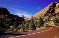
South section, view of a winding park road; Zion National Park is a United States National Park located in the Southwestern United States, near Springdale, Utah. A prominent feature of the 229-square-mile (593 square km) park is Zion Canyon, 15 miles (24 km) long and up to half a mile (800 m) deep, cut through the reddish and tan-colored Navajo Sandstone by the North Fork of the Virgin River. Located at the junction of the Colorado Plateau, Great Basin, and Mojave Desert regions, this unique geography and variety of life zones allow for unusual plant and animal diversity. Source: Wikipedia; http://en.wikipedia.org/wiki/Main_Page (accessed 1/30/2008)
Type of Work
topographical view; photographSubject
contemporary (1960 to present), landscapes, parks (recreation areas), Twenty-first century
Rights
Rights Statement
Licensed for educational and research use by the MIT community only