Citadel Hill, Halifax
Download1A2-C-H-HC-A1_cp.jpg (747.2Kb)
Alternative Title
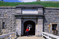
Fort George
Date
1828-1856Description
East entry gate; Citadel Hill is a glacial drumlin located on the Halifax Peninsula. It measures approximately 120 feet above sea level and affords a commanding view of the entrance to Halifax Harbour, as well as nearby George's Island and McNabs Island. A series of 4 different defensive fortifications have occupied the summit of Citadel Hill since 1749. The current star-shaped fortress, or citadel, is formally known as Fort George and was completed in 1856, following 28 years of construction. This massive masonry-construction fort was designed to repel a land-based attack by United States forces and was inspired by the designs of Louis XIV's commissary of fortifications Sébastien Le Prestre, Seigneur de Vauban. Source: Wikipedia; http://en.wikipedia.org/wiki/Main_Page (accessed 2/8/2008)
Type of Work
fortificationSubject
architectural exteriors, military, war, British Colonial
Rights
Rights Statement
Licensed for educational and research use by the MIT community only