Mount Washington State Park: Topographic Views
Download2A2-SP-MW-A9_cp.jpg (504.8Kb)
Date
2003Description
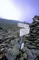
A path sign, with piles of stones near by, just below the summit or around 6000 feet; The mountain is located in the Presidential Range of the White Mountains, in Coos County, New Hampshire. It is the third highest state high point in the eastern U.S. at 6,288 ft (1,917 m), after Mount Mitchell, North Carolina - 6,684 ft (2,037 m) - and Clingmans Dome, Tennessee - 6,643 ft (2,025 m) - and is the most prominent peak in the Eastern United States. While nearly the whole mountain is in the White Mountain National Forest, an area of 59 acres (0.24 square km) surrounding and including the summit is occupied by Mount Washington State Park. Source: Wikipedia; http://en.wikipedia.org/wiki/Main_Page (accessed 2/1/2008)
Type of Work
photograph; topographical viewSubject
contemporary (1960 to present), landscapes, mountains, parks (recreation areas), Twenty-first century
Rights
Rights Statement
Licensed for educational and research use by the MIT community only