| dc.coverage.spatial | Creation Site: Seattle, Washington, United States, North and Central America, | en_US |
| dc.coverage.temporal | 2004 (creation) | en_US |
| dc.creator | Gilchrist, Scott | en_US |
| dc.date | 2004 | en_US |
| dc.date.accessioned | 2013-04-12T18:39:33Z | |
| dc.date.available | 2013-04-12T18:39:33Z | |
| dc.date.issued | 2004 | en_US |
| dc.identifier | 208046 | en_US |
| dc.identifier.other | archrefid: 891 | en_US |
| dc.identifier.uri | http://hdl.handle.net/1721.3/115920 | |
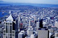
| dc.description | View of north Seattle, showing Queen Anne Hill with the Space Needle and Seattle Center in the middle right; Seattle is a coastal port city and the largest city in the Pacific Northwest region of the United States. It is located in the state of Washington between an arm of the Pacific Ocean called Puget Sound and Lake Washington, about 96 miles (155 km) south of the Canada-United States border in King County, of which it is the county seat. As of 2006, the city had an estimated population of 582,174 and an estimated metropolitan area population of approximately 3.2 million. Source: Wikipedia; http://en.wikipedia.org/wiki/Main_Page (accessed 1/30/2008) | en_US |
| dc.rights | © Scott Gilchrist, Archivision, Inc. | en_US |
| dc.subject | architectural exteriors | en_US |
| dc.subject | cityscapes | en_US |
| dc.subject | contemporary (1960 to present) | en_US |
| dc.subject | seascapes | en_US |
| dc.subject | City planning | en_US |
| dc.subject | Transportation | en_US |
| dc.subject | Twenty-first century | en_US |
| dc.title | Seattle: Aerial Topographic Views | en_US |
| dc.type | image | en_US |
| dc.rights.access | Licensed for educational and research use by the MIT community only | en_US |
| dc.identifier.vendorcode | 1A2-US-SE-AE-A4 | en_US |
| vra.culturalContext | American | en_US |
| vra.technique | photography | en_US |
| vra.worktype | photograph | en_US |
| vra.worktype | topographical view | en_US |
| dc.contributor.display | Scott Gilchrist (Canadian photographer, born 1960) | en_US |


