Freedom Trail: Topographic Views
Download1A2-US-B-FT-A3_cp.jpg (479.3Kb)
Date
1997Description
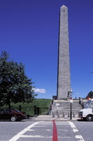
View showing the use of a painted red line to mark the Freedom Trail; The Freedom Trail is a red (mostly brick) path through downtown Boston, Massachusetts which leads to sixteen significant historic sites. It is a 2.5 mile (4 km) walk from the Boston Common to the Bunker Hill Monument in Charlestown and is popular with tourists. Part of the Freedom Trail overlaps with the much longer Boston Harbor Walk. The Freedom Trail is a unit of Boston National Historical Park. The freedom trail was originally conceived in 1958 by the local journalist William Schofield, who has been promoting the idea of linking important local landmarks with a pedestrian trail since 1951. Source: Wikipedia; http://en.wikipedia.org/wiki/Main_Page (accessed 2/10/2008)
Type of Work
photograph; topographical viewSubject
cityscapes, contemporary (1960 to present), historical, City planning, Twentieth century
Rights
Rights Statement
Licensed for educational and research use by the MIT community only