MIT Libraries homeMIT Libraries logoDome

MIT
View Item 
  • Dome Home
  • Visual Collections
  • Architecture, Urban Planning, and Visual Arts
  • View Item
  • Dome Home
  • Visual Collections
  • Architecture, Urban Planning, and Visual Arts
  • View Item
JavaScript is disabled for your browser. Some features of this site may not work without it.

Boston: Bunker Hill Neighborhood; Topographic Views

Scott Gilchrist (Canadian photographer, born 1960)
Thumbnail
Download1A2-US-B-BHN-B1_cp.jpg (687.7Kb)
Alternate file
1A2-US-B-BHN-B1_sv.jpg (2.506Mb)
1A2-US-B-BHN-B1_tm.jpg (21.27Kb)
URI
http://hdl.handle.net/1721.3/115798
Date
2003
Description
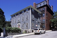
View looking down a typical street on Bunker Hill; Charlestown is a neighborhood of Boston, located on Boston Harbor between mouths of Charles and Mystic rivers; is oldest part of Boston; was almost destroyed in Battle of Bunker Hill. Source: Thesaurus of Geographic Names (Notes) [website]; http://www.getty.edu/research/conducting_research/vocabularies/tgn/ (accessed 1/30/2008)
Type of Work
photograph; topographical view
Subject
architectural exteriors, cityscapes, contemporary (1960 to present), City planning, Housing, parks (recreation areas), Twenty-first century
Rights
© Scott Gilchrist, Archivision, Inc.
Rights Statement
Licensed for educational and research use by the MIT community only
Metadata
Show full item record

Collections
  • Architecture, Urban Planning, and Visual Arts

Browse

All of DomeCommunities & CollectionsBy Issue DateCreatorsTitlesSubjectsThis CollectionBy Issue DateCreatorsTitlesSubjects

My Account

LoginRegister
MIT Libraries homeMIT Libraries logo

Find us on

Twitter Facebook Instagram YouTube RSS

MIT Libraries navigation

SearchHours & locationsBorrow & requestResearch supportAbout us
PrivacyPermissionsAccessibility
MIT
Massachusetts Institute of Technology
Content created by the MIT Libraries, CC BY-NC unless otherwise noted. Notify us about copyright concerns.