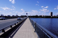
Boston: Charles River; Topographic Views
Gilchrist, Scott

Download1A2-US-B-BCR-C6_cp.jpg (496.2Kb)
Date
2003Description
View looking north towards MIT on the Mass Avenue Bridge; The Charles River is a small, relatively short river in Massachusetts, USA, that separates Boston from Cambridge and Charlestown. It is fed by about 80 brooks and streams and several major aquifers as it flows snakelike for 80 miles (129 km), starting at Echo Lake in Hopkinton, through 22 cities and towns in eastern Massachusetts before emptying into Boston Harbor. It is the most densely populated river basin in New England. Source: Wikipedia; http://en.wikipedia.org/wiki/Main_Page (accessed 1/30/2008)
Type of Work
photograph; topographical viewSubject
architectural exteriors, cityscapes, contemporary (1960 to present), City planning, Rivers, topographical views, Twenty-first century
Rights
Rights Statement
Licensed for educational and research use by the MIT community only