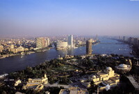
Cairo: Aerial Topographic Views
Gilchrist, Scott

Download1A2-EG-C-CA-B1_cp.jpg (540.6Kb)
Date
2003Description
View looking south over Zamalek Island and up the Nile, with Cairo at far left and the Opera complex at lower right; Largest city in Africa; built by Arabs as military camp at Al-Fustat in 642; new part built by Fatimid dynasty 968; reached greatest prosperity as trade and cultural center 13th century; taken by Ottoman Turks 1517; held by French 1798-1801; evacuated by British in 1946. It is now the largest metropolis in the Arab world. The demographic explosion since the beginning of the 20th century has opened a new chapter in the history of the city. Although it has not lost its economic vitality, overpopulation and a boom of small industries overload its insufficient infrastructure and threaten its historic monuments. Source: Grove Art Online; http://www.groveart.com/ (accessed 1/18/2008)
Type of Work
photographSubject
cityscapes, contemporary (1960 to present), Aerial photography in city planning, Twenty-first century
Rights
Rights Statement
Licensed for educational and research use by the MIT community only