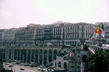
Boulevard Che Guevara
Download176430_cp.jpg (1.264Mb)
Alternative Titles
Boulevard de la République
Boulevard Ernesto Che Guevara
Boulevard de l'Impératrice
Rue du Rempart du Sud
Date
2013-04-02Description
Originally conceived during the urban redevelopment after colonization as the "Rue du Rempart du Sud" to serve as a main artery on the waterfront for harbor access, transportation, and military protection. A first sketch of the road was presented in 1837 and appeared in later planning documents, but the project wasn't commissioned until 1860 as the "Boulevard de l'Imperatrice" and was completed in 1866 according to the plans of Charles Frederic Chasseriau. After the 1870 revolution, it was called Boulevard de la Republique. general view, elevated view of boulevard, showing arcades, 1993
Type of Work
BoulevardSubject
Arcades, Roads, Transportation, Architecture --Algeria, Avenues, Africa, North, Waterfronts, Architecture, French colonial, Boulevards, Maghreb
Rights
Rights Statement
All rights reserved
Item is Part of
143157