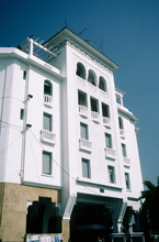
Avenue Mohammed V
Laprade, Albert; Laforgue, Adrien; Forestier, Jean Claude Nicolas; Prost, Henri

Download176304_cp.jpg (1.334Mb)
Alternative Titles
Sharia' Muhammad al-Khamis
Boulevard Mohammed V
Avenue Dar al-Makhzen
Date
1917-1932Description
This is the main artery of Rabat, running from intersecting Avenue Laalou in the north, where one of the city gates was demolished, and ending at the Jamaa Al-Souna in the South. It encompasses what used to be known as rue el Gza, Bab Jdid and Bab Teben, avenue Dar el Makhzen, cours Lyautey and avenue des Touarga. A primarily residential area, it became the administrative center of Morocco under the French protectorate. It runs through the old Medina and the Ville Nouvelle and was conceived by city planners working under Marshal Lyautey as a means to join the traditional and modern parts of the city. The first commercial construction began in 1915, and it became an administrative center when construction started buildings for the operations of the French authorities. The Parliament, Central Bank, main strain station, Central Post Office, are all found along this street, in between gardens, cafes, palm trees and shopping. In the Protectorate era a tram ran the length of the Avenue. A new system was restored to the Avenue in 2011. exterior, central, tallest part of a mixed-use building on corner of Zankat Abou Inan showing geometric patterns in stucco facade, 1993
Type of Work
AvenueSubject
Gardens, Roads, Capital cities, Pedestrian areas, Morocco --History --1912-1956, Architecture --Morocco, Avenues, Architecture, French colonial, City planning --Morocco, Trams, Maghreb, Apartment houses, Arcades, Geometric patterns, Windows, Columns, Stucco, Horseshoe arches, Roof terraces
Rights
Rights Statement
All rights reserved
Item is Part of
143077